News
What happens when you grab an interdisciplinary group of skilled and highly motivated hackers, give them the task of improving the bus system of the city; and grant them full autonomy over the transport raw data which they had been trying to put their hands on for the last years?
This is exactly what happened during Sao Paulo’s first open transport hackathon between October 26 and 27 of 2013. The event brought together experts, software developers and technologists to conceive, design and develop prototypes for the most pressing transport problems in Sao Paulo.
The government laid three primary challenges to be tackled by participants, which were:
- How can the user/citizen aid SPTrans in enforcing the quality of the bus system and monitor the expected level of service from the bus’ companies
- Use data mining techniques to help evaluate the effectiveness of new bus corridors, identify historic patterns in bus speeds, conflicting intersections, and use fare card data to provide insights on the demand -per bus route and times of the day-
- Innovate in the provision of information to users, either at bus stops, applications, or through any other creative means
The data used during the hackathon had been part of SPTran’s bus fleet AVL data for the last 11 years. AVL devices on the 15,000 buses fleet pin-pointing their location every 80 seconds. Also, the bilhete unico, Sao Paulo’s fare card, has been in existence since 2004. Today 13 million bus trips are done daily using the fare card.
Sao Paulo also has a GTFS file of their transit network with schedules and timetables, which had been feeding Google Transit since 2008, but none of this information had been shared with the public before.
This opening of the data was neither fortuitous nor incidental. We (the WB) obviously take some credit for helping SPTrans open up their data, but it is clear that it also responded to events such as the protests related to the bad quality of the bus service and public transport tariffs, in June 2013, where transparency and accountability played a fundamental role.
Where’s my bus?
I had the luck of being invited, along with my colleague Georges Darido, to be part of the judging committee of the hackathon and I can say without hesitation that the results were astounding.
Of the 60 hackers participating on 15 different teams, the judging commission chose three winners according to the participant’s adherence to these parameters: public interest, crowdsourcing elements connecting with the passenger, innovation and technical strength (including whether the code was open license and replicable).

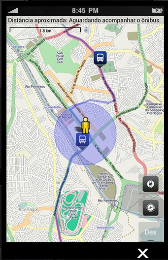
- First place was awarded to NanoIT whose project was, “Cadê o Onibus?” (pictured above) an app that incorporated four new functionalities such as routes, schedules, bus stops, estimated arrival time (associated with traffic data when available) and notification services to notify when a bus is arriving to the stop. An innovative factor in their proposal was to use the person in charge of collecting the fare, the cobrador, to use a tablet device to inform how crowded the bus is, report traffic anomalies within their route, and to directly notify incidents to the police or firefighters, all in real-time. They also included assessment reports, for SPTrans’ consumption, using all these variables and suggested to produce a QR code to be displayed at bus stops to provide information in different languages about the real-time location of the bus in that stop. If you want to know more about this project find its code here.
- The second place was for the project TrillaSP. The team developed an application where the user plays nice and well-thought game to provide feedback about the bus service in five categories: cleanliness, crowdedness, comfort, and service delivery from the driver and the cobrador. The rating information goes directly to SPTRans’ tweeter account, which is the mechanism they use for receiving complaints.
- Third place was for the application InsPorte from the team Bad Request. They also empower users to provide feedback about the conditions of the bus, providing the user a broader range of tools for this assessment, such as the ability to send pictures of the conditions of the bus shelters or the buses itself. Find the project code here.
- The last project, “De Olho no Onibus”, is a demo tool, which allows to see which lines are more crowded by time of the day), supervise if the bus concessionaires are delivering the level of service programmed, and monitor the quality of the AVL data by finding inconsistencies in the location of the buses, or other anomalies. Here is the project’s demo (use route 199 to run the animation), the project’s presentation, and the code use to build the prototype.
Other proposals included performance dashboards and tools for estimating pseudo origin-destination matrices based on boarding and alighting of riders. Here is where all the hackathon’s proposals can be found.
I firmly believe that even though the infrastructure gap between cities in developing and developed countries is many decades apart, technology is perhaps the most important pillar that can help cities converge and help them provide better levels of service (than the current ones) with less infrastructure than their more developed counterparts.
Technology, opening of data and allowing civil society to get involved in a timely manner can be a real game changer for cities in developing countries. In Sao Paulo we saw how citizens were looking for ways to participate more actively in the enhancement of the public transport and opening of the data was a window for achieving that.
